

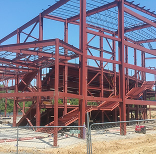
ENGINEERING
Goodwin-Lasiter, Inc. DBA GLS was established in 1983 in Lufkin, Texas and celebrated 40 years in business this past year. Founded with a desire to provide high-quality architectural, engineering, and surveying services to the East Texas Region, GLS has grown into one of the largest and most experienced firms in East and Central Texas.
We have maintained steady growth and operate as a full-service design firm with professional disciplines including Architecture, Engineering, Interiors, Landscape and Surveying. Today, GLS provides services on a wide range of professional disciplines for both Public and Private endeavors including:
-
Educational Facilities
-
Religious Facilities
-
Commercial Buildings
-
Retail Buildings
-
Athletic Facilities
-
Civic Facilities
-
Planning
-
Parks
-
Structural Systems
-
Public Works (Municipal & Rural)
-
Surveying (Topographic / Boundary / Platting)
-
Industrial Consulting
We have served Clients in Texas, Arkansas, Oklahoma, Louisiana, Kentucky, Ohio, New Mexico, and Virginia.

Civil

GLS offers civil engineering to provide paving, drainage, detention, utilities and traffic flow designs. Our team also develops plans for site development permitting.


Structural & MEP

Our Structural and MEP engineering services are integrated into any design project we do adding value to your investment.


Land Surveying

Our professional surveying division provides design and boundary surveying to enable a closely coordinated design effort. With this in house service, GLS obtains the necessary topographic and boundary information.
Topographic Surveys are used for design while the boundary survey is used to create a plat and/or re-plat for the specific project. Using GLS for your surveying needs provides optimal coordination and scheduling for our team.

GIS Services

GLS is here to help!
GLS can revolutionize your operations by providing a centralized, accessible platform for managing and analyzing your systems. Our GIS-as-a-Service solution offers a dynamic, interactive view of your infrastructure, eliminating the need for dedicated in-house GIS expertise.
With our platform, you can easily access and share information about your systems, ensuring that everyone has the most up-to-date data. By streamlining your processes and improving collaboration, GIS can significantly enhance your overall efficiency and decision-making.
What is GIS?
Geographic Information Systems (GIS) are tools that allow us to collect, organize, analyze, and visually represent spatial data. By linking location information with descriptive data, GIS helps us understand patterns, relationships, and geographic context. This technology is used across various fields, from urban planning to environmental science, to make informed decisions and improve efficiency.


How does GIS work?
GLS will create a digital twin of your infrastructure (utilities, buildings, assets, etc.) by digitizing your paper maps, importing CAD drawings, and/or using GPS receivers to get GPS locations of data points that you need. Data collected with GPS receiver will be within 1-2 feet of accuracy or higher if acquired using survey grade equipment if that precision of accuracy is required. Necessary tabular data would also be imported and integrated into the GIS system.
The result is an interactive map with the latest data available on any device (phone/tablet/computer) connected to the Internet, to all departments (both in office and field), at any time. Users will be able to zoom in and out as needed, and have detailed information about that asset with the ability to attach PDFs or pictures of the asset or document. Users will also have the ability to print a report from the map for third parties that don't have permission for viewing.
GLS can also add any PAD (Public Available Data) to the system such as datasets from the County Appraisal District, USGS lidar data (for planning purposes only), FEMA Flood Maps, etc., depending on your location and needs. We can use a variety of basemaps including street maps and aerial maps from ESRI to make the GIS data as helpful to you as possible.


How can you benefit from our GIS services?

1
Ditch Paper
GIS can streamline your operations by eliminating the need for paper maps and files. By integrating data from spreadsheets, existing maps, and the expertise of your team, you can create a centralized, up-to-date spatial database.

2
Real-Time Updates
Unlike traditional map-based systems, GIS offers real-time updates, ensuring that your information is always accurate and accessible. This eliminates the time-consuming process of manually updating and distributing paper maps.

3
Anytime, Anywhere
With GIS, you can quickly access the data you need, whenever and wherever you are. This will save you time, reduce costs, and improve decision-making.

Contact us for your next project! Send us an email, or contact your area's local office today.